Under
Construction

Sujet
: La
construction de l'hôtel de Salm à Paris
Auteur : Anonyme
Date : 19e siècle
Lieu : Paris, Musée Carnavalet
Auteur : Anonyme
Date : 19e siècle
Lieu : Paris, Musée Carnavalet
Understanding History:
Geographic Information Systems
historical
geography
economic geography
cultural geography thearda.com
social geography
input-output analysis and geography:
institutional networks (the geography of flows {personnel, materiel, money, semiotics})
Supply chain management (Wiki)
time geography
economic geography
cultural geography thearda.com
social geography
input-output analysis and geography:
institutional networks (the geography of flows {personnel, materiel, money, semiotics})
Supply chain management (Wiki)
time geography
govtrack.us This site accesses Congressional voting data, and maps every vote on every bill and motion. A critical resource.
A Cultural Geography of the United States and Canada: Map Gallery. This is a great site, and should be consulted regularly.
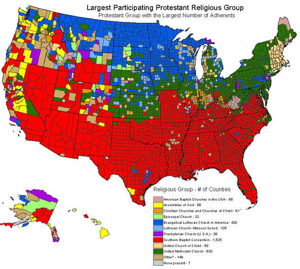
Religious Congregations & Membership, 2000 Glenmary Research Center
U. S. Map Collection Geology.com
David Leip's Atlas of U. S. Presidential Elections another great site
Evangelical
Protestants, Mainline Protestants, and Catholics (Boyer)
2008 Presidential Election, by
state


from WorldAtlas.com
Results, 2008 (New York Times)
Note the regional concentrations. Compare this with the maps above and below.
This map of population density by county (unit of analysis) should be actively borne in mind and linked to as often as necessary whenever electoral politics, social issues, economic change, and anything else having to do with people and communities comes under scrutiny.


The map to the right, pupulation density by metropolitan area, should be compared with the map above, popultion density by county. These maps should be borne in mind when looking at electoral maps

Dynamic Maps of Bank Card and Mortgage Delinquencies in the United States, Federal Reserve Bank of New York
1. us census site
2. CNN/NYT/ election centers
further study of metropolitan areas ("Detroit" = Wayne+Oakland+Macomb) uses data on the
3. county subdivision
4. census tract

Population
Density, Detroit-Ann Arbor-Flint CMSA (Consolidated Metropolitan
Statistical Area), by County Subdivision
